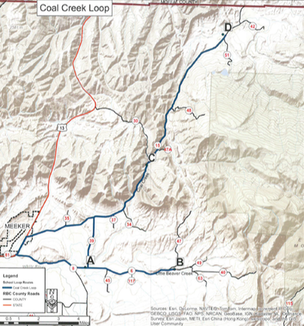
This historic loop takes you past the first rural school site and ends near the historic Milk Creek Battlefield. You travel near the White River for a short distance, through valleys and canyons full of hay fields, cattle, sheep and beautiful scenery. The loop is about 47 miles.
[NO FACILITIES AVAILABLE]
[NO FACILITIES AVAILABLE]
Coal Creek Loop:
DRIVING INSTRUCTIONS:
Begin from the corner of 6th Street and Market Street (State Highway 13). Driving northeast (toward Craig), drive 1.7 miles to the intersection of County Road 8 and State Highway 13, taking the right turn onto County Road 8. Drive 3.1 miles to the intersection of County Road 6 and turn left on to County Road 6. Drive .6 miles to see the Coal Creek School (Point A) still standing as of 2013. There is a pull off on the left to the school. The Rio Blanco County Historical Society owns this school and is hoping to restore it. GPS N40°O1.866 W107°49.042
Continue on County Road 6 for 4.2 miles to see Little Beaver School still standing as of 2013 on the left(Point B). This is private property. GPS N40°01.896 W107°43.958
Turn around and follow County Road 6 back 4.1 miles to intersection of County Road 39. Turn right on County Road 39 for 2.6 miles to the stop sign. Turn right at the T intersection with County Road 15. Travel 4.1 miles to Upper Coal Creek site (Point C). GPS N40°06.407 W107°45.702
Continue driving 7.9 miles on County Road 15 to the Milk Creek Battle site on your left. The Thornburg School sign is near the picnic table and is the viewpoint(Point D) of the restored Thornburg School. The Thornburg School is on private property. GPS N40°12.071 W107°41.451
This is the turnaround point for the Coal Creek Loop. Follow County Road 15 back 15.8 miles to the intersection of State Highway 13. Turn left on to Highway 13 and drive 2.7 miles back to the starting point in Meeker.