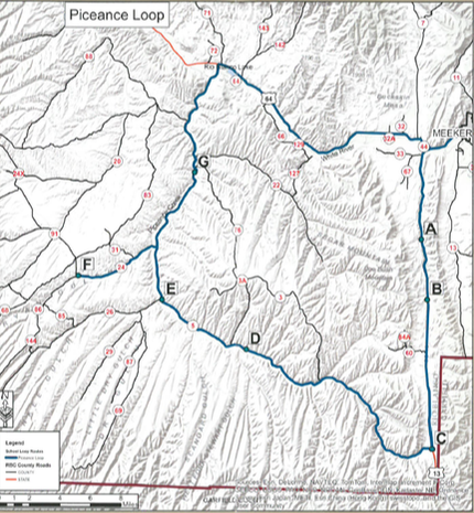
State Highway 13 was known as the “Government Road.” As you travel along County Road 5 look for remaining grasslands, the basis for the Ute name, Piceance, “land of tall grass.” People who came to homestead and establish schools were grain farmers, cattle ranchers and cowboys. A few were also a part of the beginning of the mineral resource development in the oil fields and coal mines. As you view present scenery, imagine the past and contemplate the future. This is an extensive tour covering about 96 miles.
[THERE ARE FEW SERVICES ON THIS LOOP. SO, PLEASE PLAN AHEAD FOR FUEL, FOOD AND WATER.]
[THERE ARE FEW SERVICES ON THIS LOOP. SO, PLEASE PLAN AHEAD FOR FUEL, FOOD AND WATER.]
Piceance Creek Loop:
Josephine Rural School
Petrolite Rural School
Rio Blanco Rural School
Stewart Rural School
Rock Rural School
Bar D Rural School
Burke Rural School
Petrolite Rural School
Rio Blanco Rural School
Stewart Rural School
Rock Rural School
Bar D Rural School
Burke Rural School
DRIVING INSTRUCTIONS:
Begin at the corner of 6th Street and Market Street (State Highway 13). Drive south (toward Rifle) go 9 miles to the Josephine School site on your left (Point A).
GPS N39°56.133 W107°57.985
Driving south on State Highway 13 go 4 miles to the Petrolite School site on your right (Point B). GPS N39°52.730 W107°57.367
Continue driving down State Highway 13 for 9.7 miles to the Rio Blanco School site on your right at the southwest corner of the intersection of State Highway 13 and County Road 5 (Point C). GPS N39°44.221 W107°56.752
Go back to County Road 5 and turn left on it. Drive 16.5 miles to the Stewart School site on your right (Point D). This is a very busy road so pick a pull off carefully. GPS N39°49.591 W108°10.679
Beyond this point travel 6.9 miles to Rock School still standing as of 2013 on your right (Point E ).Pull off at the Piceance Creek Clinic road and walk or drive up to the school on the hill. It is leased to a private company so just look around the outside. GPS N39°49.592 W108°10.679
Return to County Road 5 and turn right. Go 3.5 miles on County Road 5 and then turn left on to County Road 24. Go 5.8 miles to Bar D School still standing as of 2013 on your right (Point F). GPS N39°53.459 W108°23.327
Turn around at this point and go back 5.8 miles to County Road 5. Turn left on County Road 5 and drive 5.8 miles to the site of the Burke School on your left (Point G ). There is a pull off before the sign on the left. Traffic is heavy on this road so be aware. GPS N39°59.522 W108°14.958
At this point you can turn around and go back the way you came or continue on County Road 5 about 8.5 miles until it comes to State Highway 64. Turn right onto State Highway 64 and go about 18 miles to the intersection of State Highway 64 and State Highway 13. Turn left onto State Highway 13 and go 2.6 miles back to Meeker.