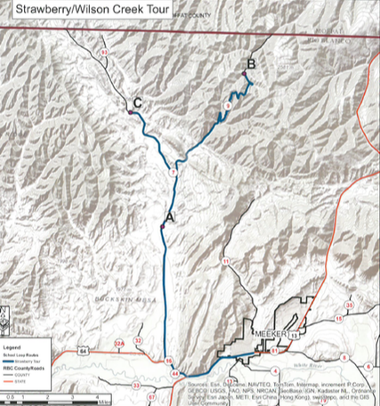
Remoteness and oil field development kept schools open in this area years after most rural districts sent students to attend Meeker schools. Enjoy a scenic drive through Strawberry Creek ranching area combined with a climb to 8,000 feet in elevation and the Wilson Creek oil field camp area presently owned and operated by Chevron. The tour is about 45 miles.
Strawberry and Wilson Creek Loop:
Driving Instructions:
Begin at the corner of 6th Street and Market (State Highway 13). Drive south (toward Rifle) for 2.6 miles to the intersection of State Highway 64 and State Highway 13. Turn right on to State Highway 64 and drive for 1.3 miles to County Road 7 on your right.
Turn right on County Road 7 and drive 5.2 miles to the Lower Strawberry School site on your right (Point A). Pull off at the Cemetery dirt road. The Strawberry Cemetery is located up the dirt road on the hill above the sign if you want to visit it. GPS N40°06.381 W107°58.802
Continue driving on County Road 7 for 2.2 miles and turn right onto County Road 9. This is a maintained gravel road with sharp curves; steep drop offs and often called the “Little Burma Road”. Drive 7.4 miles on County Road 9 to the Wilson Creek School sign on your left ( Point B). If you look up the dirt road in front of the Gas Plant Office you will see a line of pine trees. Wilson Creek School site was just before the pine trees. This is private land so do not enter. GPS N40°11.928 W107°55.209
Turn around and go back down County Road 9 for 7.4 miles until you meet County Road 7. Turn right on County Road 7 and drive 3.4 miles to the White Rock School on your right (Point C). White Rock School is still standing as of 2013. It is located on a bad curve so be aware of traffic. GPS N40°10.459 W108°00.359
This is your turn around point for the Strawberry Loop. Follow County Road 7 about 12 miles back down to State Highway 64. Turn left onto State Highway 64 and drive 1.3 miles to the intersection of State Highway 64 and State Highway 13. Turn left on State Highway 13 and drive 2. 6 miles back to Meeker.