Traveling along the sparkling waters of the White River offers all the beauty of this designated Scenic Byway while viewing rural schools. This rich valley attracted ranchers, farmers, and sportsmen in the late 1880’s and early 1900’s. Various resorts and homesteads were established which led to the building of several schools. This is considered a day tour even without the drive to Stillwater School site. Consider including fishing, hiking and picnics in your visit along this 85 mile tour.
85 Mile Round Trip Self-Guided Tour with Miller Creek, Elk Creek, Buford, Stillwater, Marvine Rural Schools.
[There are few services on this loop. So please plan ahead for fuel, food and water.]
85 Mile Round Trip Self-Guided Tour with Miller Creek, Elk Creek, Buford, Stillwater, Marvine Rural Schools.
[There are few services on this loop. So please plan ahead for fuel, food and water.]
Up the White River Loop:
Miller Creek Rural School
Elk Creek Rural School
Buford Rural School
Stillwater Rural School
Marvine Rural School
Elk Creek Rural School
Buford Rural School
Stillwater Rural School
Marvine Rural School
DRIVING INSTRUCTIONS
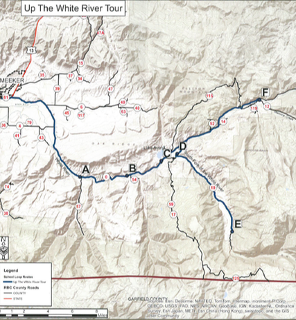
Begin from the corner of 6th and Market (State Highway 13). Drive northeast (toward Craig for 1.7 miles to the intersection of County Road 8 and State Highway 13 taking the right turn onto County Road 8, the Flat Tops Trail Scenic Byway. Go 3.3 miles to a scenic overview of the White River Valley on your right. Read about the history of The White River Valley. Drive another 2.9 miles up the road to the Meeker Agency sign on your right and read more about the history of the Meeker area. 6.2 miles further, you come to the Miller Creek School site on the right. (Point A on the map.) There is a good place to pull off near the sign.
GPS N39°56.856 W107°46.367
Continue driving 4.7 miles on County Road 8 to see the Elk Creek School(Point B on the map) on the left. The address is 14965.
GPS N39°56.961 W107°41.997
Proceed 3.3 miles on County Road 8 to the first Buford School site on your left below the Lake Avery Dam (Point C). GPS N39°58.094 W107°38.809
Now drive 2 miles on County Road 8 to County Road 17. It will be the first road to your right. Turn right onto County Road 17 and go .7 miles on County Road 17 to the Buford School still standing as of 2013 on the left side (Point D). Pull off and read the historic sign about Buford School. GPS N39°58.626 W107°37.341
This part of the tour is optional as it is a 20 mile round trip on a well maintained gravel road. Continue driving on County Road 17 for .2 mile to County Road 10 on your left. Turn left on County Road 10 and continue on the gravel road for 10 miles to the Hill Creek Trailhead on your left and site of the Stillwater School (Point E). The Stillwater School sat among the pine trees up this dirt road to the right. GPS N39°53.165 W107°32.048
At this point turn around and follow County Road 10 back to County Road 17. Turn right on County Road 17 and drive 1 mile to County Road 8.Turn right on County Road 8 and go 8.1 miles to the first road on the right past mile marker 28. There is no County Road marker on this road. Turn right on this road and go about .1 mile to the Marvine School site on your left (Point F). GPSN40°02.607 W107°29.820
This is the turning around point for the Upriver Loop. Follow the road back to County Road 8. Turn left on County Road 8 and go 28.5 miles to the intersection of County Road 8 and State Highway 13. Turn left and drive about 1.8 miles back to the Town of Meeker.


