Touring the sites of all the Rangely area schools, offers a diversity of terrain. Resources of vast grazing lands, accessible timber, some tillable soil, desired minerals, and most importantly the water, provided opportunities for homesteading which inevitably led to school houses.
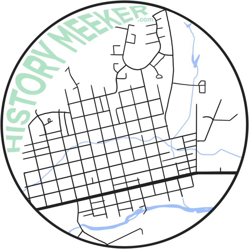
Beginning at the Rangely Museum, this route heads west then loops back through town before going east to include the Douglas Creek and Angora areas, then returning to Rangely.
The tour is about 140 miles but plan for additional time for other historic sites, hiking, rest stops and picnicking.
Beginning at the Rangely Museum, this route heads west then loops back through town before going east to include the Douglas Creek and Angora areas, then returning to Rangely.
The tour is about 140 miles but plan for additional time for other historic sites, hiking, rest stops and picnicking.
Rangely Loop:
Lower Rangely Rural School
Hefley Rural School
Ridgeway-Banta Rural School
Wolf Canyon Rural School
Douglas Creek Rural School
CP Hill Rural School
Upper Rangely Rural School
Angora Rural School
Yellow Creek Rural School
Hefley Rural School
Ridgeway-Banta Rural School
Wolf Canyon Rural School
Douglas Creek Rural School
CP Hill Rural School
Upper Rangely Rural School
Angora Rural School
Yellow Creek Rural School
DRIVING INSTRUCTIONS:
Begin at the Rangely Museum, 434EastMain (State Highway 64). Turn left onto East Main (State Highway 64). Drive 1.5 miles to the Lower Rangely School site on your right. (Point A).The school was located within this block.
GSP N40°05.259 W108°48.175
Continue on Highway 64 for .5 mileto River Road on your left. Turn left onto River Road and go .1 mile to West Main Street. Turn rightontoWest Main Street and go one block to the intersection of Half Turn Road and West Main Street.The (Hefley) Rangely School site (Point B) was across the road from this intersection.
GPS N40°05.253 W108°48.863
At this point turn around and go back to West Main Street and River Road. Turn right on River Road which will turn into County Road 2, a maintained gravel road.Go 10 miles to the Ridgeway-Banta School site on your right (Point C). There is a pull off and turn around area near the sign.
GPS N40°03.399 W108°58.431
Take a scenic trip back to Rangely (on maintained gravel roads) turn around at this point and go back on County Road 2 for 1.6 miles to County Road 202. Turn left onto County Road 202 and go across the bridge to the intersection of County Road 102. Turn right onto 102and go 6.1 miles to a stop sign. Turn left ontoCounty Road 130 and go .8 mile to Highway 64.Turn right on Highway 64 and go 1.5 miles to County Road 46 on your left. Turn left on County Road 46 and go .7 mile to County Road 23A on your right.
The bridge you see was the original bridge crossing the White River. There was a temporary school near the south side of this bridge in 1911. County Road 23A turns into North White Avenue.When you get to the intersection of North White and Highway 64 turn left and travel 1.8 miles to Highway 139. Turn right on Highway 139 and go 28 miles to Douglas Creek School site also called Wolf Canyon School on your right (Point D).The horse shed is still standing as of 2013. There is a small pull off near the sign. Be aware of traffic on this road.
GPS N39°42.687 W108°47.898
At this point turn around and go back on Highway 139 for 2 miles to the original site of the Douglas Creek School on your right (Point E). There is a good pull off near the sign.
GPS N39°44.466 W108°47.627
Continue back on Highway 139 for 26 miles to Highway 64. Turn right onto Highway 64 and go .1 mile to Airport Roadand County Road 101. Turn left onto Airport Road and go .7mile to C. P. Hill School site on your right (Point F).There is a good pull off near the sign.
GPS N40°.05.646 W108°.46.349
Turn around at this point and go back to Highway 64.Turn left on Highway 64 and travel 4.5 miles to the Upper Rangely School site (Point G). Turn into the picnic area and parking lot for Taylor Dam and Kenney Reservoir. The Upper Rangely School site is east and above the parking lot.
GPS N40°06.903 W108°42.425
Return to Highway 64 and turn left. Travel 11.3 miles to Angora School site on your right (PointH). The school sat on the hill above the road. There is a good place to pull off near the sign.
GPS N40°10.635 W108°34.525
This next part of the trip is optional as Yellow Creek School is 9.4 miles up Highway 64 on the right (PointI). The Yellow Creek School is still standing as of 2013.
GPS N40°10.101 W108°24.484
There is no good place to pull off or turn around near the school site. You need to go past the school about .6mile. On your right is County Road 89 which is a good turn around point. This is the end of the Rangely Tour. Drive west on State Highway 64 about 28 miles back to the Rangely.